Category:Maps of the Magellan-Elcano circumnavigation
Jump to navigation
Jump to search
Deutsch: Karten, die die erste Weltumsegelung (1519–1522) von Ferdinand Magellan und Juan Sebastián Elcano zeigen
English: Maps showing the first documented world circumnavigation by Ferdinand Magellan and Juan Sebastián Elcano (1519–1522)
Media in category "Maps of the Magellan-Elcano circumnavigation"
The following 54 files are in this category, out of 54 total.
-
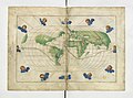
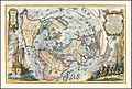
 1544 Battista Agnese Worldmap.jpg 3,585 × 2,450; 2.41 MB
-
-
 Cebu map attached to the Pigafetta's report.jpg 1,870 × 2,781; 1.53 MB
-
 El hemisferio hispánico.jpg 3,783 × 2,566; 3.18 MB
-
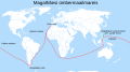
 Erste Weltumsegelung unter Magellan und Elcano.png 1,425 × 625; 41 KB
-
 Erste Weltumsegelung von Magellan und Elcano.png 1,425 × 625; 68 KB
-
 First circumnavigation simplified.svg 2,246 × 1,139; 119 KB
-
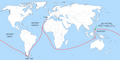
 First Voyage Round The World Pacific.jpg 3,012 × 2,312; 1.23 MB
-

-
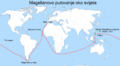
 Itinerario de Magallanes y Elcano.jpg 1,536 × 906; 285 KB
-
 Lehen zirkumnabigazioa.gif 1,174 × 709; 1.85 MB
-
 Magalhães Elcano Circum-navegação-pt.svg 749 × 380; 112 KB
-
 Magallaes itsasartea.gif 1,920 × 1,545; 130.88 MB
-
 Magallaes itsasartearen ibibidea.gif 997 × 802; 3.66 MB
-
 Magallaes-Elkano espedizioaren infografia.svg 512 × 260; 9 MB
-
 Magellan Elcano Circumnavigation-ar.svg 2,246 × 1,139; 222 KB
-
 Magellan Elcano Circumnavigation-de.svg 2,246 × 1,139; 219 KB
-
 Magellan Elcano Circumnavigation-en.svg 2,246 × 1,139; 219 KB
-
 Magellan Elcano Circumnavigation-es.svg 2,246 × 1,139; 1.02 MB
-
 Magellan Elcano Circumnavigation-fr.svg 2,246 × 1,139; 258 KB
-
 Magellan Elcano Circumnavigation-hu.svg 2,246 × 1,139; 365 KB
-
 Magellan Elcano Circumnavigation-ru.svg 2,249 × 1,181; 224 KB
-
 Magellan Elcano Circumnavigation-zhs.svg 2,246 × 1,139; 211 KB
-
 Magellan seyexet.png 800 × 443; 109 KB
-
 Magellan's voyage (Indonesian version).svg 2,488 × 1,378; 4.13 MB
-
 Magellan's voyage AZ.svg 2,488 × 1,378; 3.92 MB
-
 Magellan's voyage EN.svg 2,488 × 1,378; 4.13 MB
-
 Magellan's voyage ET.svg 2,488 × 1,378; 4.11 MB
-
 Magellan's voyage HE.png 800 × 400; 81 KB
-
 Magellan's Voyage HR.PNG 2,000 × 1,108; 391 KB
-
 Magellan's voyage HU.svg 2,488 × 1,378; 4.15 MB
-
 Magellan's voyage HY.svg 2,488 × 1,378; 4.11 MB
-
 Magellan's voyage IT.svg 2,488 × 1,378; 4.13 MB
-
 Magellan's voyage MK.svg 2,488 × 1,378; 4.11 MB
-
 Magellan's voyage PL.svg 2,488 × 1,378; 4.11 MB
-
 Magellan's voyage PT.svg 2,488 × 1,378; 4.11 MB
-
 Magellan's voyage SR.svg 2,488 × 1,378; 4.11 MB
-
 Magellan's voyage zh-classical.svg 2,488 × 1,378; 4.33 MB
-
 Magellan's voyage-fr.svg 2,998 × 1,900; 4.29 MB
-
 Magellan-Harita-Tr.jpg 1,884 × 892; 193 KB
-
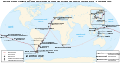
 Magellan-Map-En.png 1,357 × 643; 112 KB
-
 Magellan-Map-No.png 1,357 × 643; 74 KB
-
 Nova-Guinea-1540.JPG 960 × 720; 100 KB
-
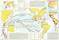
 Outlines of European History - The Voyages of Discovery.png 2,793 × 1,711; 1.1 MB
-
 Primer viaje en torno al globo.jpg 1,519 × 1,098; 269 KB
-
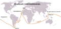
 Primera vuelta al mundo, 1519-1522.jpg 1,388 × 839; 242 KB
-
-
 Strait of Magellan's discovery 1520 mk.svg 3,275 × 2,635; 844 KB
-
 Strait of Magellan's discovery 1520.svg 3,275 × 2,635; 678 KB
-
 The discovery of America (1892) (14797584383).jpg 2,272 × 1,206; 246 KB
-
 Viagem de Fernão de Magalhães - Museu Naval.jpg 1,280 × 960; 248 KB
-
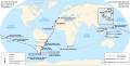
 Voyages of Magellan.png 805 × 398; 274 KB
-
 Weltumsegelung von Ferdinand Magellan und Juan Sebastian Elcano.png 1,500 × 885; 350 KB
-
 Weltumsegelung von Magellan und Juan Sebastian Elcano.png 1,500 × 885; 297 KB

.jpg)


.jpg)


.svg)


_(14797584383).jpg)


